 |
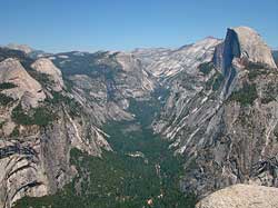
| Yosemite's U-shaped canyons are evidence of glaciation. Tenaya canyon with Half Dome on the right, and North Dome and Basket Dome on the left. |
Yosemite National Park Geology
Yosemite is a glaciated landscape, and the scenery that resulted from the interaction of the glaciers and the underlying rocks was the basis for its preservation as a national park. Iconic landmarks such as Yosemite Valley, Hetch Hetchy, Yosemite Falls, Vernal and Nevada Falls, Bridalveil Fall, Half Dome, the Clark Range, and the Cathedral Range are known throughout the world by the photographs of countless photographers, both amateur and professional. Landforms that are the result of glaciation include U-shaped canyons, jagged peaks, rounded domes, waterfalls, and moraines. Glacially-polished granite is further evidence of glaciation, and is common in Yosemite National Park.
Topographically, the Sierra Nevada is an asymmetric mountain range with a long, gentle west slope and a short, steep east escarpment that culminates in the crest of the Sierra Nevada. It is 50 to 80 miles wide and extends in altitude from near sea level along its west edge to more than 13,000 feet along the crest in the Yosemite area, and more than 14,000 feet along the crest in the Sequoia-Kings Canyon area. The highest peak in the Sierra Nevada, and in the continental United States, can be found to the south: Mount Whitney in Sequoia National Park. Geologically, the Sierra Nevada is a huge block of the Earth's crust that has broken free on the east along a bounding fault system and has been uplifted and tilted westward. This combination of uplift and tilt, which is the underlying geologic process that created the present range, is still going on today.
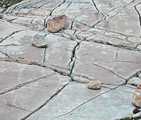 |
| Jointed granite. |
Massive granite dominates the Yosemite area and much of the Sierra Nevada as well. Mount Hoffmann and most of the terrain visible from it are composed of granite, formed deep within the Earth by solidification of formerly molten rock material and subsequently exposed by erosion of the overlying rocks. Because of its massiveness and durability, granite is shaped into bold forms: the cliffs of Yosemite and Hetch Hetchy Valleys, many of the higher peaks in the park, and the striking sheeted domes that can form only in massive, unlayered rock. Although granite dominates nearly the entire length of the Sierra, the granite is not monolithic. Instead, it is a composite of hundreds of smaller bodies of granitic rock that, as magma (molten material), intruded one another over a timespan of more than 100 million years. This multiplicity of intrusions is one of the reasons why there are so many varieties of granitic rock in Yosemite and the rest of the Sierra. The differences are not always apparent to the casual observer, but they are reflected in sometimes subtle differences in appearance and in differences in response to weathering and erosion acting on the rocks.
Layered metamorphic rocks in the foothills at the west edge of the park and along the eastern margin in the summit area are remnants of ancient sedimentary and volcanic rocks that were deformed and metamorphosed in part by the invading granitic intrusions. Other metamorphic rocks that once formed the roof beneath which the granitic rocks solidified were long ago eroded away to expose the granitic core of the range, and only small isolated remnants are lefts. Because Yosemite is centered on this deeply dissected body of granite, metamorphic rocks are sparse; they occupy less than 5 percent of the area of the park.
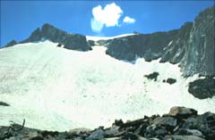 |
| Lyell Glacier, East Lobe. NPS Photo. |
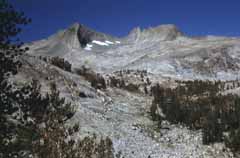 |
| McClure Basin from Upper Lyell Base Camp. NPS Photo. |
Although many of today's general landforms existed before modification by glacial action, some of them surely did not. Can you imagine the Yosemite landscape with no lakes? Virtually all the innumerable natural lakes in the park are the result of glacial activity. But even these lakes are transitory, doomed to be filled with sediment and become meadows; many lakes already have undergone this transformation. Yosemite Valley itself once contained a lake.
The geologic story of Yosemite National Park can be considered in two parts: (1) deposition and deformation of the metamorphic rocks and emplacement of the granitic rocks during the Paleozoic and Mesozoic; and (2) later uplift, erosion, and glaciation of the rocks during the Cenozoic to form today's landscape.
Copyright © 2004-2006 Calvin & Rosanna Hamilton. All rights reserved.