New Mexican Culture
New Mexico's history has led to a wondrous blending of cultures: from the Puebloan and other Native American groups that have been here for thousands of years, through the Spanish and Mexican heritage moving in several centuries ago, to the more recent additions of Northern European decent during the last two centuries. Each has provided customs and traditions that make the Southwest so unique and beloved a place to be.
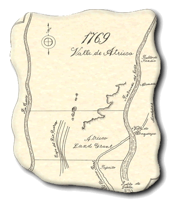
The Atrisco Land Grant
The Spanish land tenure or land grant system was a practice brought from Spain to establish economic development and settlement in New Mexico. Prominent individuals requested large parcels of land and their ownership was granted by a Spanish official or by the King of Spain. The Rio Grande and its surrounding valley were lush with native vegetation therefore Spanish settlers considered this land ideal for settlement, agricultural and grazing purposes. The Coronado expedition of 1540, led by Captain Hernando de Alvarado, marked the earliest sightings of what would later become known as the Valle de Atrisco in the present Albuquerque area.
Early History of Valle de Atrisco.
Spanish history of the Valle de Atrisco begins in 1598 with the arrival of Don Juan de Oñate of Spain who entered the northern frontier of New Mexico via El Camino Real for purposes of claiming the territory on behalf of the king of Spain. In the early 1600s a number of Spanish estancias (farms) and ranches dotted the area of the Rio Grande valley between Sandia Pueblo to the north and Isleta Pueblo to the south. By 1632 the first Spanish settlement in Albuquerque was on the site of present day Old Town.
 Spanish settlement came to a halt in 1680 with the outbreak of the
Pueblo Revolt. The revolt was the result of forced labor and religion
imposed on the Pueblo Indians by Spanish colonists and missionaries.
Twelve years later, Don Diego de Vargas succeeded in reoccupying New
Mexico.
Spanish settlement came to a halt in 1680 with the outbreak of the
Pueblo Revolt. The revolt was the result of forced labor and religion
imposed on the Pueblo Indians by Spanish colonists and missionaries.
Twelve years later, Don Diego de Vargas succeeded in reoccupying New
Mexico.
Within the ranks of de Vargas' volunteer army was a native New Mexican, Don Fernando Duran y Chaves II. In 1692, De Vargas awarded Don Fernando an 82,000-acre grant on the lands where his father, Don Pedro, once lived on the west side of the Rio Grande. This land became known as the Atrisco Land Grant.
El Camino Real.
The oldest, most historic road in the United States is El Camino Real, also known as "The King's Highway" or "The Royal Road." In 1598 Oñate's first expedition into New Mexico walked along El Camino Real naming areas of the land as they journeyed north. Many of the names declared by Oñates' expedition are still used today such as Belen, Bernalillo, and Isleta. Since the late 16th century Spanish explorers, soldiers, colonists, missionaries, and merchants traveled north from Chihuahua, Mexico to Santa Fe, New Mexico via El Camino Real. Except for the 12 year Pueblo Revolt period when the Spanish forbade travel on the highway, El Camino Real was in constant use until 1881 when the Santa Fe Railroad completed laying the tracks between Albuquerque, New Mexico and El Paso, Texas.
For over four centuries this course-whether you call it El Camino Real as the Spanish, or El Camino Constitucional (Constitutional Highway) as the Mexican's, or Interstate 25 as the American's-served and continues to be the route of choice connecting people, cultures, and commerce throughout the western United States. Its historical significance has been acknowledged by Congress who designated El Camino Real de Tierra Adentro (The Royal Road of Interior Land) a National Historical Trail in October of 2000.
Spanish Settlement in Atrisco.
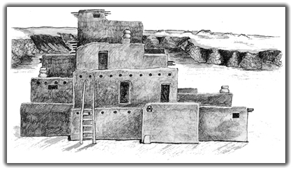
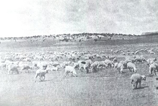
Settlers began to move to the village of Atrisco in 1703; In 1706 the Villa de Albuquerque was established. Settlers in the Atrisco valley built their haciendas (homes) along the Rio Grande. The villagers were highly reliant upon the resources of the land for their survival. The native grasses that grew in the canyons and rincons (corners) were critical for grazing sheep and cattle. Lands were cultivated and irrigated and used to grow corn, chile, wheat, squash, alfalfa, and beans. The land grant settlers relied on grazing sheep and other livestock for food and clothing. By 1760, over 200 people had settled in Atrisco, and the valley was becoming crowded. As a result in, 1768, the Atrisco Land Grant expanded to include the mesa top grasslands.
 |
 |
 Other land grants included the Alameda grant to the north. The Elen
and Carnual grants to the est, the Parajito grant to the south and many
others up and down the Rio Grande Valley and throughtout New Mexico.
Other land grants included the Alameda grant to the north. The Elen
and Carnual grants to the est, the Parajito grant to the south and many
others up and down the Rio Grande Valley and throughtout New Mexico.
In 1848, the Treaty of Guadalupe Hidalgo was signed, and New Mexico officially became part of the United States. The treaty honored existing land grants. For the people of Atrisco, this secured the land grant and provided increased economic opportunity.
The Atrisco Land Grant Today.
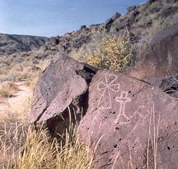
In 1967 the Atrisco Land Grant was incorporated into Westland Development Company Inc. which manages approximately 56,000 acres of Atrisco's land holdings. Of the monument's 7,236 acres, nearly 2,000 acres in the southern area called Mesa Prieta were once part of the Atrisco Land Grant. Among the volcanic rocks that form the canyons within the Atrisco grant, a considerable number of historic petroglyphs include Christian crosses, livestock brands, and Spanish initials.
For over 400 years, the Atrisqueños (Atrisco land grantees) have witnessed a number of economic and political changes, from the Pueblo Revolt to New Mexico's independence from Spain, and New Mexico's inclusion as a territory of the United States in 1846. Today, Atrisco remains one of the oldest existing land grants in the United States and one of very few Spanish Colonial grants still presently owned by the heirs of the original Spanish settlers. The Atrisco Land Grant continues to be a proud part of Spanish heritage in New Mexico.
Terms related to the Atrisco Land Grant
Sierra de Sandia: Located in the eastern elevations of Albuquerque at 10,678 ft. above sea level, the mountains comprise of granite, white limestone, and a variety of vegetation. The name derives from its historical association with Sandia Pueblo.Río Puerco: Spanish meaning hints more at "muddy river", as it is seasonally full. Located 16 miles west of the Río Grande from Albuquerque, the east bank of the Río Puerco formed the westernmost boundary of the Atrisco Land Grant in 1768 when the grant was expanded beyond the Ceja del Río Puerco, or the horizon formed by the ridge south of Albuquerque's west mesa.
Villa de Alburquerque: Believed to be the Spanish derivation of the Latin term albaquercus. Founded in 1706, the Villa de San Felipe de Neri de Alburquerque was named in part for Viceroy Francisco Fernández de la Cueva Enríquez, Duke of Alburquerque, and partly in honor of King Felipe V's coronation. San Felipe de Neri was his patron saint. In modern times, the extra "r" has been dropped. The word Albuquerque is believed to have been corrupted by English speaking arrivals to New Mexico in the 19th century.
Ceja: Spanish meaning brow or ridge. This word refers to the Ceja del Río Puerco of the Atrisco Land Grant. The Ceja del Río Puerco is the western horizon of the city south of the west mesa. From the Río Puerco looking eastward toward Albuquerque, one can see the horizon formed from that viewpoint. The cumbre or ridge is the ceja.
Mesa: Spanish for plateau in southwestern United States. Much of Albuquerque's west mesa is included in Petroglyph National Monument.
Valle: Spanish for valley.
Río Grande del Norte: Spanish for "large river of the north", originates in the San Juan Mountains of southwestern Colorado. It flows southward through the middle of New Mexico and empties into the Gulf of Mexico.
Copyright © 2003-2006 Calvin & Rosanna Hamilton. All rights reserved.