

PLATE XVIII.40
Cedar Bank Works, Ross County, Ohio.
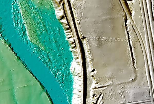 |
| This is a Lidar image of Cedar Bank Works as it appears today. Most of the site is destroyed, but the southern berm can clearly be seen with a ghost image of the northern berm. The platform mound is no longer visible. |
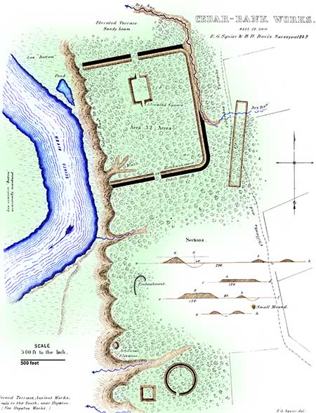 THIS work is situated upon the table lands bordering the Scioto river, at a point
five miles above the town of Chillicothe, and about a mile above the works last
described. It consists of a wall and outer ditch, which constitute three sides of a
parallelogram. The fourth side is protected by a natural bank or bluff, seventy
feet high, and so steep as to admit of no ascent, except at one point where it has
been gullied by the flow of water.
THIS work is situated upon the table lands bordering the Scioto river, at a point
five miles above the town of Chillicothe, and about a mile above the works last
described. It consists of a wall and outer ditch, which constitute three sides of a
parallelogram. The fourth side is protected by a natural bank or bluff, seventy
feet high, and so steep as to admit of no ascent, except at one point where it has
been gullied by the flow of water.
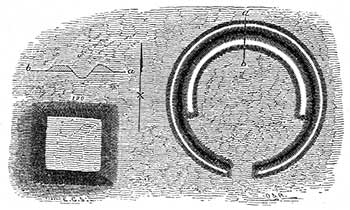
The walls of this work are about six feet high by forty feet base; the ditch five feet deep by forty wide. The ditch upon the longer or eastern side is formed, for two thirds of its length, by a "runway" or water-course. It is here from eight to ten feet deep. The wall upon this side is fourteen hundred feet long. The northern and southern walls are each ten hundred and fifty feet in length, and placed at right angles to the first; the southern extending to the very edge of the bluff, the northern terminating within twenty-five feet of it. It is possible that a fourth wall originally bounded the enclosure on the west, which has been destroyed by the river, in its encroachments. There are gateways, each sixty feet wide, at the centres of the northern and southern sides. Covering the northern gateway, and two hundred feet interior to it, is an elevated square, two hundred and fifty feet long by one hundred and fifty broad, and four feet high. It is ascended from the ends by graded ways, thirty feet broad, and in all respects resembles the truncated pyramids or "elevated squares" of the Marietta Works (Plate XXVI).
On the line of the southern embankment, and three hundred feet distant from the main work, are singular parallel walls, eight hundred and seventy feet long and seventy feet apart, connected at the ends. These walls have no ditch, and have been partially obliterated by the Chillicothe and Columbus turnpike, which passes through them. In the timbered land, where they are undisturbed, they are between two and three feet high.
|
| Figure 9. |
It is difficult to determine the character of this group of works. The principal enclosure partakes of the nature of a defence; but the broad gateways and the regular terrace embraced in the walls, are features hardly consistent with the hypothesis of a military origin. The long parallel lines, found in connection with this and other works, are entirely inexplicable in their design and purposes. The most plausible suggestion concerning them is, that they were devoted to the celebration of certain games; they may, however, have been connected with religious observances. It has been suggested that the gully or "wash" towards the river was originally a graded way to the water, and that its present irregularity has been occasioned by the rains and storms of centuries.
It is a singular fact that there are no mounds of magnitude in connection with these works. Upon the opposite side of the river, however, there are a large number, as will be seen in the succeeding Plate.
40. Indicated by the letters B and C, in Map, Plate II.
Copyright © 2009 Calvin & Rosanna Hamilton. All rights reserved.